
Moggy's Notes
EAW_TTD.dat
Places the non-target ground objects in the EAW terrain
EAW_TTD.dat seems to contain 59 groups of records, each one of which relates to one of the 59 tiles which make up the EAW landscape.
The order of the records is the set by the code number (used in EAW.TM) of the north orientation of the tile, as set out in DOM's notes. Accordingly 00 is the tile BNfield8, 01 is BNgrass, 02 is BNwater. Some confirmation of this scheme is found in the fact that the third group of records in EAW_TTD.dat, for the BNwater tile is composed wholly of zeros (i.e. no possibility of any terrain mods)
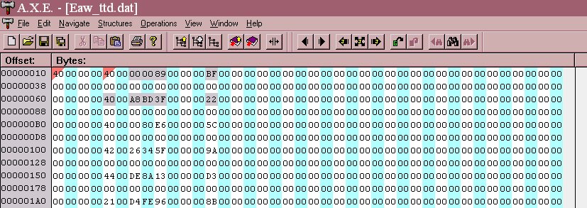
[the "record" for tile BNfield8.ter set up in AXE, with line length set to 40 bytes showing the structure of the records]
In the above screenshot above EAW_TTD.dat is set up in a hex editor with a line length of 40(d) starting at the marker for the very first group of records for the tile BNfield8. The offset for the marker is 10(h) and the value is "40" i.e. in the first group there are 64 records to follow.
I have highlighted the first two lines, which , code for the first row from the top left hand corner of the tile.
For the first fourlines the numbers are 40 or 42. These are the Tmod codes for the farm buildings and the Manor House. For the remaining lines in this first group the numbers are 20, 21, 23, 24, 25, 26, 27. These are the Tmod numbers for the various trees (singles, doubles, clumps, large, small).
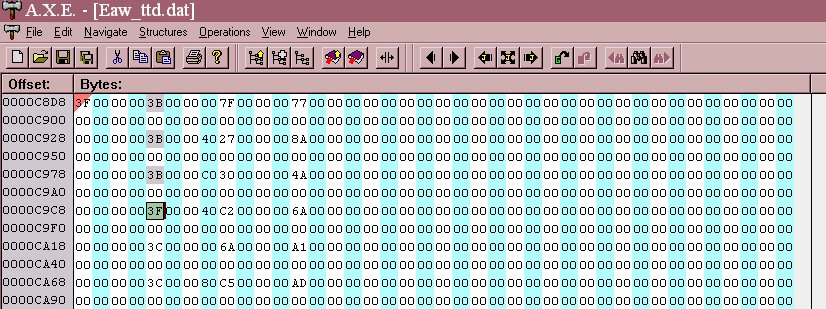
[the "record" for tile BNalcty.ter set up in AXE, with line length set to 40 bytes showing the structure of the records]
If we look at record group OA in the screenshot above, the town tile BNalcty, the first numbers in each record are 3B, 3F, 3C, 3D, 3E etc. These are the Tmod codes for the various city buildings and the Cathedral. The marker for that group of records is 3F, and there are only 63, and not 64 lines for that tile.
Every tile has a group of up to 64 lines, each of which can code for a terrain mod. The lines do not actually relate to particular parts of the tile, but use a coordinate system. Each line is in this format:
XX 00 YY YY AA 00 00 00 BB
"XX" is the Tmod number, the hexadecimal value of the filename.
"YY YY" is the orientation, with 00 00 being "north/south", 00 40 being "west/east", 00 80 being "south/north" etc.
"AA" is the first part of the coordinate (from 00 at the top of the tile to FF at the bottom), "BB" is the second part (00 on the extreme left of the tile to FF on the extreme right).
00 00 00 00 00 places the object in the top left corner of the tile,
80 00 00 00 80 places it right in the middle.
You can substitute targets tmods for the terrain objects. In the shot below I have substituted a radar tower for one of the city building blocks ...

It appears to work okay for all the static Tmods, all of which blow up quite beatifully, with the little men fleeing in all directions.
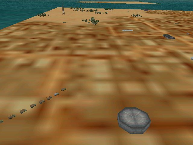
The mobile Tmods are the surprise ... If you place any of the trucks at a coordinate location, what you get is a moving column of vehicles moving in the direction of however you set the orientation. They move untill they reach the edge of the tile. In my test bed they then stop, but that may because either the neighbouring tile is a water tile, or because that tile does not also code for vehicles as terrain mods.
This works with trucks but not tanks, although clearly the tanks could be substituted for the truck filnames.
I've experimented with AA guns, and so far the light AA does not seem to work, but not sure about the heavy AA. More experimentation is required.
Return to RAF Chattenden Moggy's Home Page